|
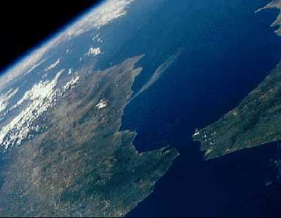
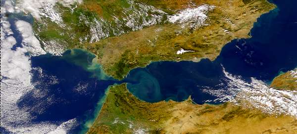
The Strait of Gibraltar is the border between Africa and
Europe, only eight miles wide (13 km) at its narrows. In
Spain, to the left, the small spike of land is the Rock
of Gibraltar; Africa is on the right side of the image.
The blue Mediterranean opens up into the distance. The
proposed mega-project of a bridge or a tunnel, which is
being evaluated in stages, would link Europe with Africa
in the early 21st Century.
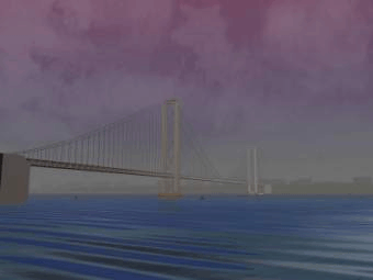
This image of a bridge is being used by RBO as a symbol for its proposed Multimedia Bridge between Africa and Europe. The image was created by Gary J Chernega for the "Internet Raytracing Competition", and it depicts one of the great engineering achievements, the Akashi Kaikyo Bridge. This bridge is the world's longest suspension bridge, at 2.43 miles in length. Located along the Kobe-Naruto route in Japan the bridge was opened in April 1998. Click on the picture to see a video. |
|
Diese Darstellung einer Brücke symbolisiert die von RBO vorgeschlagene multimediale Verbindung zwischen Afrika und Europa. Das Bild wurde digital erstellt von Gary J Chernega für den "Internet Raytracing Wettbewerb". Es zeigt die Akashi Kaikyo Brücke, die als eine der grossen Werke der Ingenieurskunst gilt. Sie ist mit 2,43 Meilen der Welt längste Spannbrücke und wurde in Japan als Teil der Kobe-Naruto-Route im April 1998 eingeweiht. Klicken Sie auf das Bild, um ein Video zu sehen. |
Here is a collection of links which present
ideas how to bridge the Strait of Gibraltar:
Renowned
bridge designer T. Y. Lin, professor emeritus at the
University of California at Berkeley
and chairman of Lin Tung-Yen China Inc.
Lin's works include numerous spans as well as the roof
structure of the Moscone Convention Center in San
Francisco, the largest underground room in the world.
Among his unbuilt designs are a bridge from Alaska to
Siberia and a five-mile wide span over
the Straits of Gibraltar.
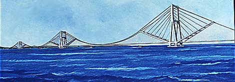
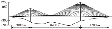
Lin
and Philip Chow blueprinted Gibraltar bridge with hybrid
cable-stayed/suspension design.
Each span would run more than 3 miles.
Textile
bridges of our time
Project of Swiss engineers for crossing the Straits of
Gibraltar
(Bridge made of carbon-fibre-reinforced compound material)
|
Geneva, 30 June-25 July 1997: The Secretary-General has the honour to transmit to the Economic and Social Council the report prepared in accordance with Council resolution 1995/48 by the Executive Secretaries of the Economic Commission for Europe and the Economic Commission for Africa on the work that has been done in connection with the project to establish a Europe-Africa permanent link through the Strait of Gibraltar. The Economic and Social Council has taken an interest in this project since 1982 following a decision by the Governments of Morocco and Spain to carry out joint studies on the feasibility of the project as part of an agreement on bilateral cooperation adopted on 24 October 1980... | |
 |
Communiqué from ITA -April 1999: Under a bilateral agreement, Spain and Morocco, through their respective agencies S.N.E.D. and S.E.C.E.G, are jointly studying the feasibility of a fixed link across the Strait of Gibraltar, presently developed as an undersea rail tunnel. |

|
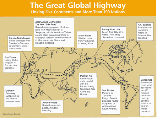
| Under discussion: The concept of a great global highway that would connect five continents and more than 100 of the world's most important cities. This proposed route extends from Scandinavia across the Great Belt to Europe, then through the proposed tunnel at Gibraltar to Africa, down the West Coast of Africa, back up the East Coast, along the eastern end of the Mediterranean, then from Istanbul to Shanghai following the historic Silk Road path, northward along the Siberian coast, through the proposed tunnel under the Bering Strait, then along the Pan American Highway and across North, Central, and South America. |
|
The Strait of Gibraltar as seen from the south
The Rock of Gibraltar was once one of the two classical Pillars of Hercules, crowned with silver columns by Phoenician mariners to mark the limits of safe navigation for the ancient Mediterranean peoples. The rocky promontory still commands the western entrance to the Mediterranean Sea, separated from North Africa only by the narrow Strait of Gibraltar. A British colony, Gibraltar occupies a narrow strip of land at the southernmost tip of the Iberian Peninsula. It is separated from the Spanish mainland by a neutral zone contained on a narrow, sandy isthmus. The rocky limestone and shale ridge known as the Rock rises abruptly from the sea, to a maximum elevation of 426 meters (1,398 feet). Because of its strategic location and formidable topography, Gibraltar serves mainly as a British fortress. The Rock has traditionally been a symbol of British naval strength. Most of its sparse land is taken up by air and naval installations, and the civilian population is small.
Fotos satélites del estrecho de Gibraltar
![]()